


PATC Shenandoah app for iPhone and iPad
Developer: International Mapping
First release : 03 Jan 2012
App size: 285.59 Mb
The Potomac Appalachian Trail Club (PATC) has a long, proud history of producing quality mapping content for the Appalachian Trail community. To reach a new wave of technologically savvy outdoor enthusiasts, the PATC teamed up with International Mapping to create this interactive navigation application. Covering the entire Shenandoah National Park area, PATC-Shenandoah encompasses maps 9, 10, and 11 from the printed PATC map series. International Mapping surrounded these trusted trail maps with a variety of navigational tools and personal customization features to help make your visit to the Shenandoah National Park more enjoyable and memorable.
Going on a hiking trip in Shenandoah National Park. Looking for an app to help you navigate all of the trails? Worried you will not have Wi-Fi access to access all of the information? Then this is the app for you as we have included everything you will need in the download!
Key Content Features:
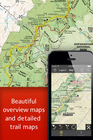
+ Full content of PATC Maps 9, 10 and 11
+ Photos and descriptions for dozens of key locations throughout the park
+ Points of Interest listings for over 1,000 locations in and around Shenandoah National Park
Key Features Include:
+ GPS tracking of your location, even without WiFi or cell reception
+ A revolutionary new trail navigation system
+ Map tools including distance, bearing and compass
+ Customized pins to record photos, comments, & locations along your hike
+ Detailed search capabilities by nearby locations and by type
+ Identify the Latitude/Longitude or UTM Coordinate for any place on the map
PATC-Shenandoah was developed by International Mapping. To learn more visit: www.internationalmapping.com
Compatibility:
+ Requires iOS 4.3 or greater
+ GPS functionality requires iPhone 3GS or later.
Latest reviews of PATC Shenandoah app for iPhone and iPad
This latest release has stripped out all useful features and left us with just the maps. Old version: you could tap out a route and have a good estimation of how long your hike would be. New version: "Tap on starting point; tap on destination; heres the route to take!". When Google/Apple maps make you do that they at least tell you how far it is. I have to get a new phone, which means I will be losing the version I liked and will be back to planning hikes in the SNP with a paper map and a pair of dividers.
Perhaps the best app to supplement your day hike or a weekend backpacking trip through SNP.
I couldnt be more excited to have this app. Im looking forward to using the GPS feature while out bushwacking this winter.
Been waiting for this capability for some time. Not only having the PATC maps in digital form but being able to know precisely where you are on the trail is quite a benefit. Even with an expensive Garmin Unit you cant tell where you located on a specific trail because Garmin only has topo maps which do not have the trails. Thanks PATC, hope to see more of your maps digitized soon. I use this app with my iPod touch and the Bad Elf GPS accessory and it works great.
The update brought custom navigation to this already awesome app. Very helpful and fun to use... If youre spending a day or more in the Park area would highly recommend this app.