

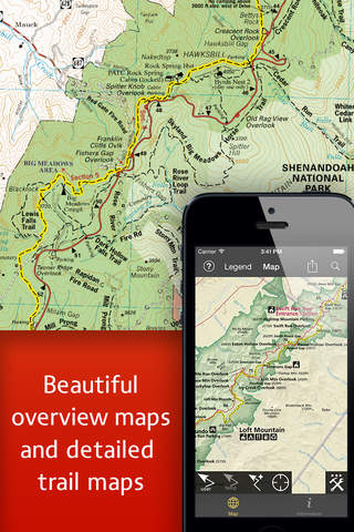


The Potomac Appalachian Trail Club (PATC) has a long, proud history of producing quality mapping content for the Appalachian Trail community. To reach a new wave of technologically savvy outdoor enthusiasts, the PATC teamed up with International Mapping to create this interactive navigation application. Covering the entire Shenandoah National Park area, PATC-Shenandoah encompasses maps 9, 10, and 11 from the printed PATC map series. International Mapping surrounded these trusted trail maps with a variety of navigational tools and personal customization features to help make your visit to the Shenandoah National Park more enjoyable and memorable.
Going on a hiking trip in Shenandoah National Park. Looking for an app to help you navigate all of the trails? Worried you will not have Wi-Fi access to access all of the information? Then this is the app for you as we have included everything you will need in the download!
Key Content Features:
+ Full content of PATC Maps 9, 10 and 11
+ Photos and descriptions for dozens of key locations throughout the park
+ Points of Interest listings for over 1,000 locations in and around Shenandoah National Park
Key Features Include:
+ GPS tracking of your location, even without WiFi or cell reception
+ A revolutionary new trail navigation system
+ Map tools including distance, bearing and compass
+ Customized pins to record photos, comments, & locations along your hike
+ Detailed search capabilities by nearby locations and by type
+ Identify the Latitude/Longitude or UTM Coordinate for any place on the map
PATC-Shenandoah was developed by International Mapping. To learn more visit: www.internationalmapping.com
Compatibility:
+ Requires iOS 4.3 or greater
+ GPS functionality requires iPhone 3GS or later.